Source: Pinterest
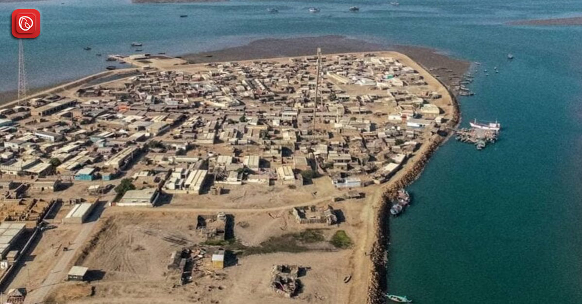
Keti Bunder was formerly a bustling port city and is currently a taluka in the Pakistani province of Sindh’s Thatta district. Situated around 200 kilometres to the southeast of Karachi, the region spans more than 60,969 hectares. The Arabian Sea, which is thought to have sunk 28 of the region’s original 42 days (clusters of settlements), has drastically changed the region’s topography. Approximately 46,137 hectares of land have been damaged, leading to a major drop in land area [WWF 2004].
Graana.com has put together a thorough overview of the city. Continue reading for more information.
| Description | Value |
| Total Area | 60,969 ha |
| Distance from Karachi | 200 km south-east |
| Households (Brick/Block) | 40% |
| Households (Thatched Huts) | 60% |
| Occupation (Fishing) | 90% |
| Occupation (Livestock Rearing) | 8% |
| Occupation (Other Sectors) | 2% |
| Literacy Rate (Overall) | 10% |
| Literacy Rate (Male) | 12% |
| Literacy Rate (Female) | 5% |
| Common Diseases | Tuberculosis, Hepatitis, Malaria |
Keti Bunder is situated in the Thatta district of Sindh province, almost 200 kilometres southeast of Karachi. This Thatta district taluka (tehsil) comprises 42 dehs (clusters of villages) covering 60,969 hectares.
The entire impacted area of Keti Bunder is estimated to be 46,137 hectares, with 28 deaths thought to have been swallowed by the sea (WWF 2004).
With 29 villages and 19 dehs, the tehsil has about 12,000 people. Before any dams or barrages were built on the Indus River, this tehsil was a port city in the past. It is currently one of the major towns along Pakistan’s coastline where residents are losing prospects for a living and the environment is deteriorating.
According to elders in the area, seawater intrusion has caused Keti Bunder town’s site to shift three times in the last 70 years.
Keti Bundar and Karachi are roughly 150 kilometres apart. The quickest alternative is to take a taxi, which takes about two hours and twelve minutes. From Karachi, there are three routes to Keti Bunder:
This town was founded in 1819 to take the position of Shah Bandar, which was sinking and having to deal with a change in the course of the Indus River.
The economic landscape of the town exhibits an impressive degree of environmental change adaption. Historically, the region’s agriculture was its main industry, supported by an abundance of freshwater from the Indus River. Prized export red rice thrived beside bananas, coconuts, melons, and other fruits.
Raising livestock boosted the local economy as well. But this delicate balance was upset when dams and barrages were built on the Indus River. Seawater crept and took over the area as freshwater flow to the area’ decreased. The area’s economic activity significantly transitioned due to this abrupt change.
The region presents a complicated picture of natural resources; it was once a healthy ecosystem. Although the area has many plants and animals, environmental changes and human activity have caused serious problems.
Once a defining feature of the town, the mangrove forests are in grave decline. Human activities have severely damaged these essential ecosystems, such as exploiting trees for firewood and reducing freshwater flow from the Indus River. Even if certain vestiges continue to exist in particular creeks, their general health is a matter of worry.
Despite environmental challenges, Keti Bunder is still an important bird habitat. Waterfowl that migrate through the Keti Bunder Wildlife Sanctuaries North and South find refuge.
Over 50,000 species, including raptors, waders, egrets, pelicans, and herons, use this area as a haven each year. Their existence serves as a reminder of how crucial it is to protect the remaining natural resources.
Keti Bunder’s marine life likewise has difficulties. There has been a reduction in the population of certain fish and prawn species; others, like the Palla fish, are almost extinct. 24 types of shellfish and 63 species of fish are documented. However, their continued existence is in jeopardy.
The town is still home to land mammals such as Indian porcupine, fishing cat, wild boar, and Asiatic jackal. The area is also home to many reptiles, including lizards, sea snakes, vipers, and cobras. The biodiversity is increased by marine mammals such as common dolphins, hump-backed dolphins, and bottlenose dolphins.
The town has year-round mild temperatures and an arid subtropical climate. Housing reflects this climate; about 60% of homes are thatched huts, and the remaining 40% are built of brick or block.
Reviving Keti Bunder has included numerous administrations. Many projects have been planned, ranging from the time of Zulfikar Ali Bhutto to the current Pakistan People’s Party (PPP) government. Rebuilding Keti Bandar’s port infrastructure has been a recurrent topic.
Following are some of the top FAQs on Keti.
Keti Bunder is primarily known for being a Wildlife Sanctuary, particularly for its vast number of water birds. During migratory seasons, the area can see up to 50,000 birds, including pelicans, egrets, herons, waders, and raptors.
“Keti” translates to “delta” in the Sindhi language, while “Bunder” means “port.” Therefore, Keti Bunder translates to “Delta Port.”
Keti Bunder is located in Thatta District, Sindh, Pakistan. Historically, the port was built on the remains of the older seaport of Debal.
Keti Bunder consists of two wildlife sanctuaries: Keti Bunder North and Keti Bunder South. These sanctuaries are renowned for their large populations of water birds.
There are three main ways to get to Keti Bunder from Karachi: car, buses, and taxi.
The distance between Karachi and Keti Bunder is approximately 150 kilometres.
Yes, historically, Keti Bunder served as a port city. However, due to sea erosion, its viability as a major port has likely diminished.
This was all about Keti Bunder. For more information, visit Graana.com.
ISLAMABAD: The Capital Development Authority (CDA) is looking to the federal government for an additional…
ISLAMABAD: The Capital Development Authority (CDA) and the Asian Development Bank (ADB) have entered into…
Islamabad: The Capital Development Authority (CDA) has announced plans to issue possession letters to allottees…
Islamabad, [24 March 2025] – Graana.com, Pakistan's leading online real estate marketplace, is proud to…
Islamabad, Pakistan – March 2025: Graana.com, Pakistan’s leading real estate platform, has proudly partnered with…
KARACHI: Sindh Local Government Minister Saeed Ghani chaired a meeting on Monday to review measures…
Welcome to Graana Blog - Pakistan’s Smartest Property Portal!
For more than a decade our intention has been to revolutionise the real estate industry in Pakistan. The same belief drove the vision of our real estate team, Graana where quality beats quantity.
We have introduced an extremely transparent and purposeful portal where we will help you buy, rent or sell your property. A place where you can sit back relax and let us market your projects and listings. We believe we have set new standards for the future of real estate in Pakistan by providing the smartest property portal.


